Tibet Facts & Districts
Tibet Facts
Tibet Demographics
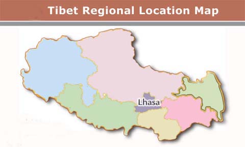
Map of Tibet
Name |
Tibet (Xizang) |
Area |
1,200,000 square kilometers (463,320
square miles) |
Time Zone |
GMT/UTC +8 |
Country Code |
86 |
Capital City |
Lhasa |
Provinces |
U-Tsang (Central Tibet), Amdo
(N.E. Tibet), Kham (S.E. Tibet) |
Administration Divisions |
2 cities and 76 counties |
Population |
6 million Tibetans and an estimated
7.5 million Chinese, most of whom are in Kham and Amdo. |
Nationalities |
Tibetan, Han, Moinba, Lhoba and
Hui |
Languages |
Mandarin (official); Tibetan
(other). The Tibetan language belongs to the Sino-Tibetan
phylum. People in U, Tsang, Kham, and Chamdo speak different
dialects. |
Religion |
Buddhist, Daoist (Taoist), Christian,
Muslim |
Neighboring Areas |
Qinghai, Sichuan, and Yunnan
Provinces; Xinjiang Uygur Autonomous Region |
Neighboring Countries |
India, Nepal, Sikkim, Bhutan,
and Burma |
Currency |
Yuan Renminbi (RMB) |
Electricity |
220 V, 50 Hz |
Electric Plug Details |
European plug with two circular
metal pins |
Products |
Wheat, highland barley, buckwheat,
iron, coal, chromites, copper, borax, salt; medical herbs |
Historically, the population of Tibet consisted of primarily ethnic
Tibetans. Other ethnic groups in Tibet include Menba (Monpa), Lhoba,
Mongols, Hui and Han Chinese. According to tradition the original
ancestors of the Tibetan people, as represented by the six red
bands in the Tibetan flag, are: the Se, Mu, Dong, Tong, Dru and
Ra.

Tibet Autonomous Region is divided into one prefecture-level city
(Lhasa) Lhasa Region and six prefectures Nakchu
Region (Nagqu), Chamdo Region (Qamdo), Nyingchi
Region (Nyinchi), Shannan Region, Shigatse
Region (Xigaz那) and Ngari Region prefectures.
|


